Home How to Get Here Services Upcoast Summers Salmon Project Photo Gallery Video Gallery Local Music

Home How to Get Here Services Upcoast Summers Salmon Project Photo Gallery Video Gallery Local Music
|
|
||
 |
Refuge Cove is located about 150 kilometers northwest of Vancouver, between
Vancouver Island and the mainland at the north end of the Strait of Georgia.
The two ways to arrive directly in Refuge Cove are by boat and by float plane. Every day during the summer, there are up to eight float plane flights to and from Seattle, Vancouver, and Campbell River. For seaplane service within British Columbia, visit www.corilair.com. For seaplane service from Seattle, visit www.kenmore.com or www.nwseaplanes.com. |
|
 |
For first-time boaters in the area, a guided learning cruise
is offered by
Richmond Sailcraft. Captain Warren Hale or one of his other skilled
instructors take you on a 9-day adventure aboard a 44-foot C&C. Besides
operating the boat while underway, you will learn about the local
conditions, including tides, weather pattFor first-time boaters in the area, a guided learning cruise
is offered by
Richmond Sailcraft. Captain Warren Hale or one of his other skilled
instructors take you on a 9-day adventure aboard a 44-foot C&C. Besides
operating the boat while underway, you will learn about the local
conditions, including tides, weather patterns, and the locations of the best
moorages.
|
|
 |
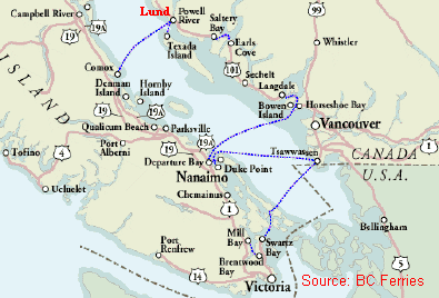
Visitors travelling by car can take
BC Ferries from Vancouver or Victoria to Powell River, and drive the
short distance northward to Lund. From there, a private boat or the
Lund Water Taxi can take visitors the rest of the way to Refuge Cove,
about 13 miles.
|